The Mountainous Province of Quirino
Planning a trip? Those who love to travel know the essence of all travel is about you and your enjoyment. Travelers know that the destination is a major part in planning a trip, experiencing and delving deeper into an unfamiliar places, people and culture is paramount.
Expand your horizons and set your sight to the Philippines, an off the beaten path travel site! An undiscovered paradise made of thousands of islands and white sand beaches all around! A tiny dot in the map of the world, and yet a haven for travelers, backpackers, retirees and even passersby.
It offers awesome tourist attractions, magnificent beaches, hot spring resorts, colorful festivals, hundreds of scenic spots and world-class hotels and facilities. Not to mention the tropical climate, the affordable prices as well as the friendly and hospitable, English-speaking people! You will be glad you came, and we’re sure, you WILL come back for more FUN in the Philippines!
QUIRINO


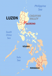
Quirino is a province of the Philippines located in the Cagayan Valley region in Luzon.
The province is generally mountainous; about 80% of the total land area is covered by mountains and highlands. The major topographic features of the province are series of connecting mountains. The Sierra Madre Mountain range provides a natural barrier on the eastern and southwestern part of the province.
Quirino province was blessed with diverse natural resources, such as awesome caves, rivers, breathtaking waterfalls, mountains and valleys, forests, plantations, and minerals. It is tagged as “where adventure begins”.
Quirino Province covers the upstream portion of the Cayagan River catchment area. It is bounded by mountains on the East (The Sierra Madre) and South. The area is heavily forested. and Quirino State College is a center for forestry education and agribusiness research.
Quirino is a landlocked province in the Philippines located in the Cagayan Valley region in Luzon and named after Elpidio Quirino, the sixth President of the Philippines. Its capital is Cabarroguis.
The province borders Aurora to the southeast, Nueva Vizcaya to the west, and Isabela to the north. Quirino used to be part of the province of Nueva Vizcaya, until it was separated in 1966.
Quirino covers a total area of 2,323.47 square kilometres (897.10 sq mi) occupying the southeastern section of the Cagayan Valley region. A landlocked province, it is situated within the upper portion of the Cagayan River basin and bounded by Isabela on the north, Aurora on the east and southeast, and Nueva Vizcaya on the west and southwest.
The Sierra Madre mountain range provides a natural barrier on the eastern and southern border of the province and the Mamparang Range on the western part. The province is generally mountainous, with about 80 percent of the total land area covered by mountains and highlands. A large portion of the province lies within the Quirino Protected Landscape.
The province has a mean annual temperature of 33.6 °C (92.5 °F). May is generally the warmest month and the wettest months are March to August, with the rest of the year being neither too dry nor too wet. Heavy, sustained rainfall occurs from September to November. Read More: https://en.wikipedia.org/wiki/Quirino
TABLE OF CONTENTS
The Mountainous Province of Quirino
The Many Waterfalls in Quirino
See The Mysterious Caves in Quirino
Interesting Places to Visit in the Quirino Province
Recent Posts
Have a Splash at the Laswitan Falls and Lagoon
LASWITAN FALLS AND LAGOON Photo from: https://www.sarwrites.com/2017/01/laswitan-lagoon.html The Laswitan Falls and Lagoon…
Cagpangi / Green Falls Lies in the Deep Medieval Forest
CAGPANGI / GREEN FALLS Photo from: https://www.solitarywanderer.com/the-green-falls/ Just about 16 kilometers…
Lanuza Surfing Grounds is a Remote Surfing Destination
LANUZA SURFING GROUNDS Photo from: https://www.surf-forecast.com/breaks/Lanuza-Rivermouth Lanuza in Surigao del Sur is…
Cagwait Beach is Often Compared to Boracay
CAGWAIT BEACH Photo from: https://www.pinterest.ph/pin/367043438355829159/ Cagwait White Beach Resort is formerly known…
Cabgan Island is Waiting to be Discovered
CABGAN ISLAND Photo from: https://en-gb.facebook.com/BaroboSurigaoDelSur27/posts Cabgan Island (or just Cabgan), is the…
Discover the Mystery of the Enchanted River
ENCHANTED RIVER Photo from: https://www.atlasobscura.com/places/hinatuan-enchanted-river Enchanted River is as mysterious as its…
