Cagayan River – the Largest and Longest River in the Philippines
CAGAYAN RIVER
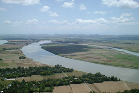
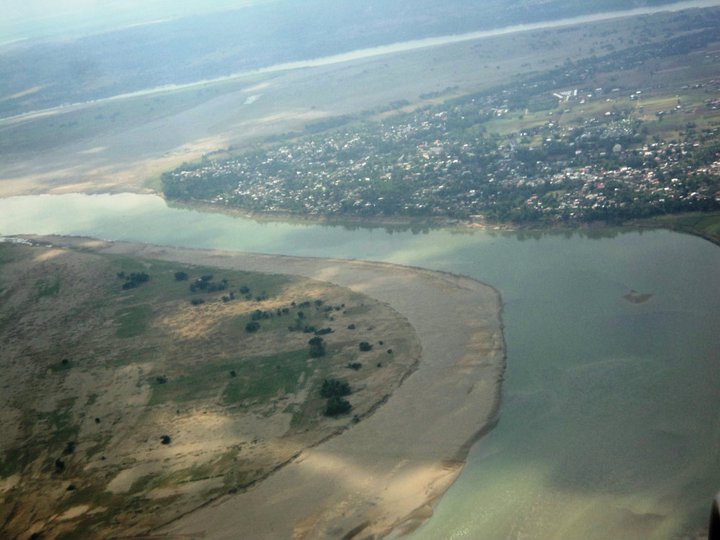
The Cagayan River is the longest and largest river in the Philippine Archipelago. It is located in the Cagayan Valley region in northeastern part of Luzon island and traverses the provinces of Nueva Vizcaya, Quirino, Isabela and Cagayan.
The Cagayan River and its tributaries are subject to extensive flooding during the monsoon season in Southeast Asia from May to October.
The average annual rainfall in 1,000 mm in the northern part and 3,000 mm in the southern mountains where the river’s headwaters lie. Water from the mountains flow down very slowly because of surface retention over the extensive flood plain, the gorges in the gently-sloping mountains and the meandering course of the river.


The Cagayan River, also known as the Rio Grande de Cagayan, is the longest and largest river in the Philippine Archipelago. It is located in the Cagayan Valley region in northeastern part of Luzon Island and traverses the provinces of Nueva Vizcaya, Quirino, Isabela and Cagayan.
The river’s headwaters are at the Caraballo Mountains of the Central Luzon at an elevation of approximately 1,524 metres (5,000 ft). Read More: https://backpackerlifestyles.blogspot.com/2016/04/cagayan-river-longest-and-largest-river.html
Cagayan River and its tributaries have deposited sediments of Tertiary and Quaternary origin, mostly limestone sands and clays, throughout the relatively flat Cagayan Valley which is surrounded by the Cordillera Mountains in the west, Sierra Madre in the east and the Caraballo Mountains in the south.
The river has a drainage area of about 27,300 km². in the provinces of Apayao, Aurora, Cagayan, Ifugao, Isabela, Kalinga, Mountain Province, Nueva Vizcaya, and Quirino.
The estimated annual discharge is 53,943 million cubic meters with a groundwater reserve of 47,895 million cubic meters.
The inundation of the Cagayan River and its tributaries have caused great loss of life and property and substantial losses to the local and national economies. The Philippine government has established several flood warning stations along the river. Experts are specifically monitoring the lower reaches from Tuguegarao to Aparri and the alluvial plain from Ilagan to Tumauini, Isabela.
Watch the Videos:
TABLE OF CONTENTS
Where is Cagayan and How to Get There
Cagayan – The Land of Smiling Beauty
Magnificent Beaches and Bodies of Water in Cagayan
Other Visitors Also Viewed:
Take the Day Off and Relax at the Minalungao National Park in Nueva Ecija
Beaches in Matabungkay, Batangas
Top Tourist Attractions in Davao del Norte Part 6
Whale Shark Watching in Donsol, Sorsogon
Catanduanes, Typhoon and Crab Capital of the Philippines
Samba de Regatta Music and Dance Event of Iloilo Paraw Regatta
Baler in Aurora – Scene of film “Apocalypse Now”
Itbog Twin Falls Offer Double Fun and Enjoyment
Recent Posts
Have a Splash at the Laswitan Falls and Lagoon
LASWITAN FALLS AND LAGOON Photo from: https://www.sarwrites.com/2017/01/laswitan-lagoon.html The Laswitan Falls and Lagoon…
Cagpangi / Green Falls Lies in the Deep Medieval Forest
CAGPANGI / GREEN FALLS Photo from: https://www.solitarywanderer.com/the-green-falls/ Just about 16 kilometers…
Lanuza Surfing Grounds is a Remote Surfing Destination
LANUZA SURFING GROUNDS Photo from: https://www.surf-forecast.com/breaks/Lanuza-Rivermouth Lanuza in Surigao del Sur is…
Cagwait Beach is Often Compared to Boracay
CAGWAIT BEACH Photo from: https://www.pinterest.ph/pin/367043438355829159/ Cagwait White Beach Resort is formerly known…
Cabgan Island is Waiting to be Discovered
CABGAN ISLAND Photo from: https://en-gb.facebook.com/BaroboSurigaoDelSur27/posts Cabgan Island (or just Cabgan), is the…
Discover the Mystery of the Enchanted River
ENCHANTED RIVER Photo from: https://www.atlasobscura.com/places/hinatuan-enchanted-river Enchanted River is as mysterious as its…

