San Juanico Bridge – Considered Philippines’ Longest
Planning a trip? Those who love to travel know the essence of all travel is about you and your enjoyment. Travelers know that the destination is a major part of planning a trip, experiencing and delving deeper into unfamiliar places, people, and culture are paramount.
Expand your horizons and set your sight to the Philippines, an off the beaten path travel site! An undiscovered paradise made of thousands of islands and white sand beaches all around! A tiny dot in the map of the world, and yet a haven for travelers, backpackers, retirees and even passersby.
It offers awesome tourist attractions, magnificent beaches, hot spring resorts, colorful festivals, hundreds of scenic spots and world-class hotels and facilities. Not to mention the tropical climate, the affordable prices as well as the friendly and hospitable, English-speaking people! You will be glad you came, and we’re sure, you WILL come back for more FUN in the Philippines!
SAN JUANICO BRIDGE


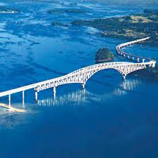
San Juanico Bridge is part of the Pan-Philippine Highway and stretches from Samar to Leyte across the San Juanico Strait in the Philippines. Its longest length is a steel girder viaduct built on reinforced concrete piers, and its main span is of an arch-shaped truss design. With a total length of 2.16 kilometers (1.34 mi), it is the longest bridge in the Philippines spanning a body of seawater, while the Candaba Viaduct (The longest bridge in the Philippines in all category) in Pampanga is under the viaduct category along the North Luzon Expressway – making the San Juanico Bridge the second longest bridge in the Philippines in all category. Read More: https://en.wikipedia.org/wiki/San_Juanico_Bridge


The San Juanico Bridge is known to be the longest bridge in the Philippines spanning a body of seawater with the length of 2.162 kilometers (1.34 mi) and width of 10.620 meters supported by 43 spans.
Since its completion in December 1972, the bridge has greatly helped the economy not only of both provinces connected but of the entire country.
The Pan-Philippine Highway was also designated as Asian Highway (AH-26) under the Intergovernmental Agreement on the Asian Highway Network, a treaty took effect on July 4, 2005 to provide a framework for coordinated development of the international highways in Asia. Have you seen the sign AH-26 along our highway lately? Now you know what it means.
San Juanico strait, which connects the islands of Samar and Leyte, is the narrowest strait in the Philippines with only two kilometers (2,000 meters) wide at its narrowest point. It is also said to be the narrowest in the world. However, Bosphorus strait, a strait that forms part of the boundary between Europe and Asia, is less than 800 meters wide at its narrowest point. Read More: http://faq.ph/10-facts-you-should-know-about-san-juanico-bridge-in-samar-and-leyte/
Going to Leyte or Samar usually would not be complete without the standard photo-stop opportunity in perhaps its single most popular landmark, the San Juanico Bridge. It spans across the San Juanico Strait that separates the islands of Leyte and Samar, and connects the so-called Pan-Philippine Highway. At 2.16 kilometres long, it is the longest bridge in the country that crosses a body of water.
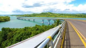
True enough, the views from the bridge are beautiful against the panoramic expanse of the San Juanico Strait, the clear blue skies, and the smooth landscape of both Leyte and Samar, which is dominated by coconut trees. Below, typical fishing activities are alive across the strait’s murky-clear waters. We even saw a family on a picnic and we were warm enough to extend some smiles and waves. Equally captivating is the architecture and design of the bridge. It also gets exciting every time vehicles, especially trucks, pass through since you can feel the bridge trembling, creating the effect of a very mild earthquake. It was also fun to note the probing and curious look of some passersby whenever they see us walking. Read More: https://www.tripzilla.ph/san-juanico-bridge-leyte-samar-philippines/1188
TABLE OF CONTENTS
The Largest Naval Battle in History Took Place in Leyte
Popular Places to Visit in Leyte
Colorful Festivals to Watch in Leyte
Having a Fun Time in Leyte
Leyte Photo Gallery
Leyte Video Collection
Recent Posts
Have a Splash at the Laswitan Falls and Lagoon
LASWITAN FALLS AND LAGOON Photo from: https://www.sarwrites.com/2017/01/laswitan-lagoon.html The Laswitan Falls and Lagoon…
Cagpangi / Green Falls Lies in the Deep Medieval Forest
CAGPANGI / GREEN FALLS Photo from: https://www.solitarywanderer.com/the-green-falls/ Just about 16 kilometers…
Lanuza Surfing Grounds is a Remote Surfing Destination
LANUZA SURFING GROUNDS Photo from: https://www.surf-forecast.com/breaks/Lanuza-Rivermouth Lanuza in Surigao del Sur is…
Cagwait Beach is Often Compared to Boracay
CAGWAIT BEACH Photo from: https://www.pinterest.ph/pin/367043438355829159/ Cagwait White Beach Resort is formerly known…
Cabgan Island is Waiting to be Discovered
CABGAN ISLAND Photo from: https://en-gb.facebook.com/BaroboSurigaoDelSur27/posts Cabgan Island (or just Cabgan), is the…
Discover the Mystery of the Enchanted River
ENCHANTED RIVER Photo from: https://www.atlasobscura.com/places/hinatuan-enchanted-river Enchanted River is as mysterious as its…
