Occidental Mindoro Mainly Produces and Exports Food Products


OCCIDENTAL MINDORO


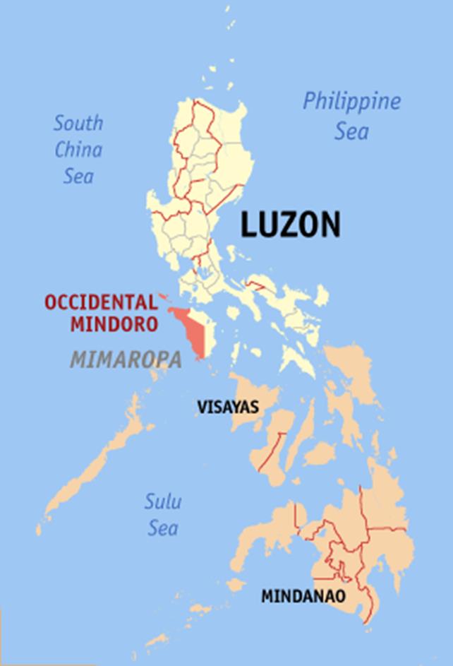
Occidental Mindoro is a province in the Philippines located in the MIMAROPA region. The province occupies the western half of the island of Mindoro. Its capital is Mamburao but the largest municipality is San Jose.


The province is bordered on the east by the province of Oriental Mindoro, and on the south by the Mindoro Strait. The South China Sea is to the west of the province and Palawan is located to the southwest, across the Mindoro Strait. Batangas is to the north, separated by the Verde Island Passage, a protected marine area and the center of the center of the world’s marine biodiversity.
Occidental Mindoro covers a total area of 5,865.71 square kilometers (2,264.76 sq mi) occupying the western section of the Mindoro island, and includes outlying islands in the northwest.
General land surface features that characterize Occidental Mindoro are mountains, rivers, hills, valleys, wide plains and some small fresh water lakes. The taller mountains can be found in the interior that it shares with Oriental Mindoro. Mountain ranges converge on the two central peaks, Mount Halcon in the north, and Mount Baco in the south. There is also a mountain known as bundok ng susong dalaga, the “Maiden’s breast mountain”, that looks like a reclined woman.
The northern part of the province has relatively fewer plains, while the southern parts have wider flatlands. Most of the plains are cultivated fields, with few remaining untouched forests. Significant hilly areas can be found rolling off in Santa Cruz in the north, and in San Jose and Magsaysay in the south. These are grassed-over rather than forested.
Occidental Mindoro is an agricultural area devoted to the production of food. Its economic base is rice production (Oryza sativa culture), a Philippine staple crop. It is the leading activity and source of seasonal employment in the province, participated in by almost 80 per cent of the population, including children.
Rice, corn, onions, garlic, salt, fishes (both wild and cultured) are some of the relatively significant surpluses produced in the province in exportable quantities. Mangoes, cashew nuts, cooking bananas (saba) and some other fruits grown in upland orchards are among the other exports of Occidental Mindoro that have traditionally contributed to its income. Peanuts are also grown in some parts of the province, as well as cassava, sweet potatoes, ginger and other minor cultivars.
Text Source: https://en.wikipedia.org/wiki/Occidental_Mindoro
Other Photos:
Watch the video:
TABLE OF CONTENTS
Occidental Mindoro Belongs to the MIMAROPA Region
Where is Occidental Mindoro and How to Get There
Occidental Mindoro Mainly Produces and Exports Food Products
Places to Visit in Occidental Mindoro
Awesome Festivals in Occidental Mindoro
How to Have Fun in Occidental Mindoro
Occidental Mindoro Photo Gallery
Occidental Mindoro Video Collection
Other Visitors Also Viewed:
Take the Day Off and Relax at the Minalungao National Park in Nueva Ecija
Beaches in Matabungkay, Batangas
Top Tourist Attractions in Davao del Norte Part 6
Whale Shark Watching in Donsol, Sorsogon
Catanduanes, Typhoon and Crab Capital of the Philippines
Samba de Regatta Music and Dance Event of Iloilo Paraw Regatta
Baler in Aurora – Scene of film “Apocalypse Now”
Itbog Twin Falls Offer Double Fun and Enjoyment
Recent Posts
Have a Splash at the Laswitan Falls and Lagoon
LASWITAN FALLS AND LAGOON Photo from: https://www.sarwrites.com/2017/01/laswitan-lagoon.html The Laswitan Falls and Lagoon…
Cagpangi / Green Falls Lies in the Deep Medieval Forest
CAGPANGI / GREEN FALLS Photo from: https://www.solitarywanderer.com/the-green-falls/ Just about 16 kilometers…
Lanuza Surfing Grounds is a Remote Surfing Destination
LANUZA SURFING GROUNDS Photo from: https://www.surf-forecast.com/breaks/Lanuza-Rivermouth Lanuza in Surigao del Sur is…
Cagwait Beach is Often Compared to Boracay
CAGWAIT BEACH Photo from: https://www.pinterest.ph/pin/367043438355829159/ Cagwait White Beach Resort is formerly known…
Cabgan Island is Waiting to be Discovered
CABGAN ISLAND Photo from: https://en-gb.facebook.com/BaroboSurigaoDelSur27/posts Cabgan Island (or just Cabgan), is the…
Discover the Mystery of the Enchanted River
ENCHANTED RIVER Photo from: https://www.atlasobscura.com/places/hinatuan-enchanted-river Enchanted River is as mysterious as its…